Thursday, January 31, 2013
Lab3
View google map (Lab3) in a larger map
The map I created is about the tour that I am going to have with my parents. It is a ten-days tour in the west. The tour covers several cities with different view of natural. The desert and the ocean will be the main focus in the sightseeing. I believe that the tour I will bring to my parents will be a fantastic trip.
Neogeography is an application that gives people a simple and fast tool of creating their own maps. The new technology that uses in neogeography is more concentrating on the interaction with people. People without any knowledge of creating a map could use the neogeography to share their lives in a map to their friends. Since the neogeography is a web-based technology, the information exchange using neogeography is world wide, which will give people a chance to see different life-style of other countries. Moreover, The geological and spatial information exchange becomes easier. Lots of spatial-based ideas will appear on the Internet, which gives professionals easy access. Volunteered spatial information will be online with detailed information.
Neogeography has many benefits not just for non-experts. On the other hand, for professionals there still exists some pitfalls of using the technology. Free access means that the information is not reliable. False data may occurred since the data is from non-experts and volunteers. As a result, the information online may be confused for non-professionals, which information trustable? Also, for professionals, even though they have the sense of distinguishing false data, but it still will take a lot of time for them, which would decreasing the efficiency for them.
Neogeography is a new technology for people to make their own maps, which will have both benefits and pitfalls. However, with a sense of suspecting data from the Internet, people who do not know about GIS or other professional application still can use to make their life simpler.
Thursday, January 24, 2013
Lab 2
1. The name of the quadrangle is Beverly Hills Quadrangle.
2. The names of the adjacent quadrangles are Canoga Park, Van Nuys, Burbank, Topanga, Hollywood, Venice, and Inglewod.
3. The quadrangle was first created at the year of 1966.
4. Selected hydrographic data from NOS/NOAA chart 18744(1964), North A,erican Datum of 1927 (NAD 27), and North American Datum of 1983 (NAD 83) are used to create the map.
5. The scale of the map is 1:24 000
6.
a) 5 centimeters on the map is equivalent 1200 meters. (5*24000/100)
b) 5 inches on the map is equivalent approximately 1.89393939394 miles. (5*24000/(12*5280))
c) one mile on the ground is equivalent to 2.64 inches. (1*12*5280/24000)
d) three kilometers on the ground is equivalent to 12.5 centimeters. (3*1000*100/24000)
7. The contour interval is 20 feet.
8.
a) the Public Affairs Building: 34°4'30''N, 118°26'20''W; 34.0750°N, 118.4389°W
b) the tip of Santa Monica pier: 34°25"N, 118°30'E; 34.007°N, 118.5°E
c) the Upper Franklin Canyon Reservoir: 34°4'46"N, 118°24'45"; 34.0794°N, 118.4125°
9.
a) Greystone Mansion (in Greystone Park); 570 feet, 173.736 meters
b) Woodlawn Cemetery; 140 feet, 42.672 meters
c) Crestwood Hills Park; 800 feet, 243.84 meters
10. UTM 11
11. 3763N, 361.5E
12. 1,000,000 meters2
13.

14.+14 °
15. Water flows southward.
16.

2. The names of the adjacent quadrangles are Canoga Park, Van Nuys, Burbank, Topanga, Hollywood, Venice, and Inglewod.
3. The quadrangle was first created at the year of 1966.
4. Selected hydrographic data from NOS/NOAA chart 18744(1964), North A,erican Datum of 1927 (NAD 27), and North American Datum of 1983 (NAD 83) are used to create the map.
5. The scale of the map is 1:24 000
6.
a) 5 centimeters on the map is equivalent 1200 meters. (5*24000/100)
b) 5 inches on the map is equivalent approximately 1.89393939394 miles. (5*24000/(12*5280))
c) one mile on the ground is equivalent to 2.64 inches. (1*12*5280/24000)
d) three kilometers on the ground is equivalent to 12.5 centimeters. (3*1000*100/24000)
7. The contour interval is 20 feet.
8.
a) the Public Affairs Building: 34°4'30''N, 118°26'20''W; 34.0750°N, 118.4389°W
b) the tip of Santa Monica pier: 34°25"N, 118°30'E; 34.007°N, 118.5°E
c) the Upper Franklin Canyon Reservoir: 34°4'46"N, 118°24'45"; 34.0794°N, 118.4125°
9.
a) Greystone Mansion (in Greystone Park); 570 feet, 173.736 meters
b) Woodlawn Cemetery; 140 feet, 42.672 meters
c) Crestwood Hills Park; 800 feet, 243.84 meters
10. UTM 11
11. 3763N, 361.5E
12. 1,000,000 meters2
13.

14.
15. Water flows southward.
16.

Wednesday, January 16, 2013
Three maps (GEOG 7 Lab 1)

URL: http://www.nationsonline.org/oneworld/map/USA/california_map.htm.
This is a reference map of transportation routes in California. The map gives us a scene of the major transportation lines in California. The places with high density of transportation lines are major cities. Los Angeles is the biggest city in California, which has the most concentrated lines in the entire map. On the other hand, the mountain area only have several principal highways, showing how hard it is to build a road on the mountains. The map is interesting for me because I like California even though I am not from here. A few years back, I was an exchanged student to the Northern area of California. It was a fantastic experience with the people and that is the time when I started to like California. After couple years living here, I have explored more about California for the easy accessibility of transportation routes.
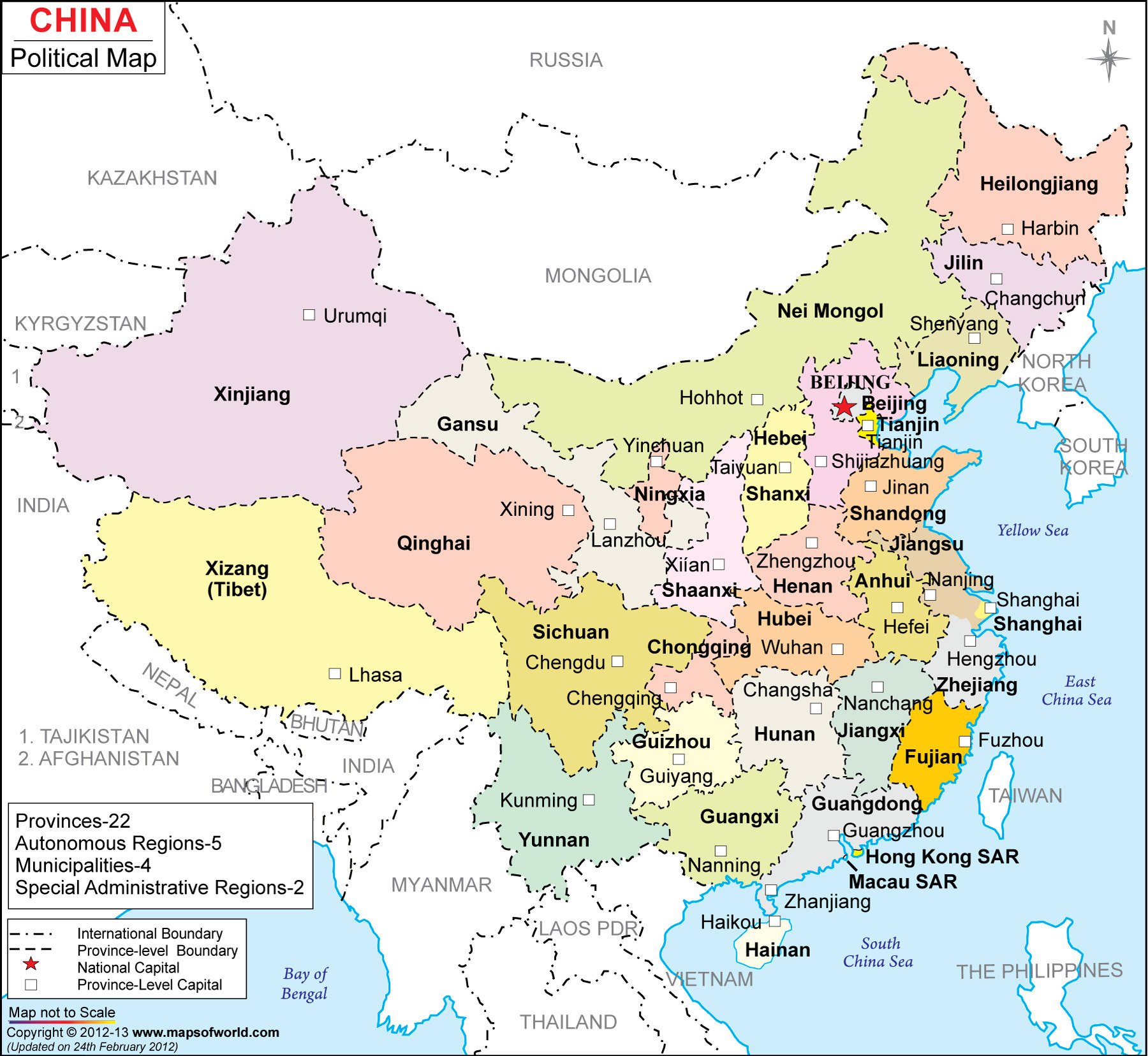
Map of China
http://www.mapsofworld.com/china/map-of-china-large.html
This is the map of China. The map shows all the provinces in China with their capitals. With different colors for different provinces, we can easily distinguish the area of the provinces. It easy to see the major cities like Beijing, Hong Kong, and shanghai. I choose this map because this is the country I come from. I'm from the city called Zhengzhou, which is in Henan province, located in the middle of China. The map gives people who do not know very much a vivid image of China. When they see this map, they would look for the major cities they know and get a rough idea of the locations of those cities. Since this is just a political map that only shows the distribution of the provinces, there is not much other information about the topographic features.
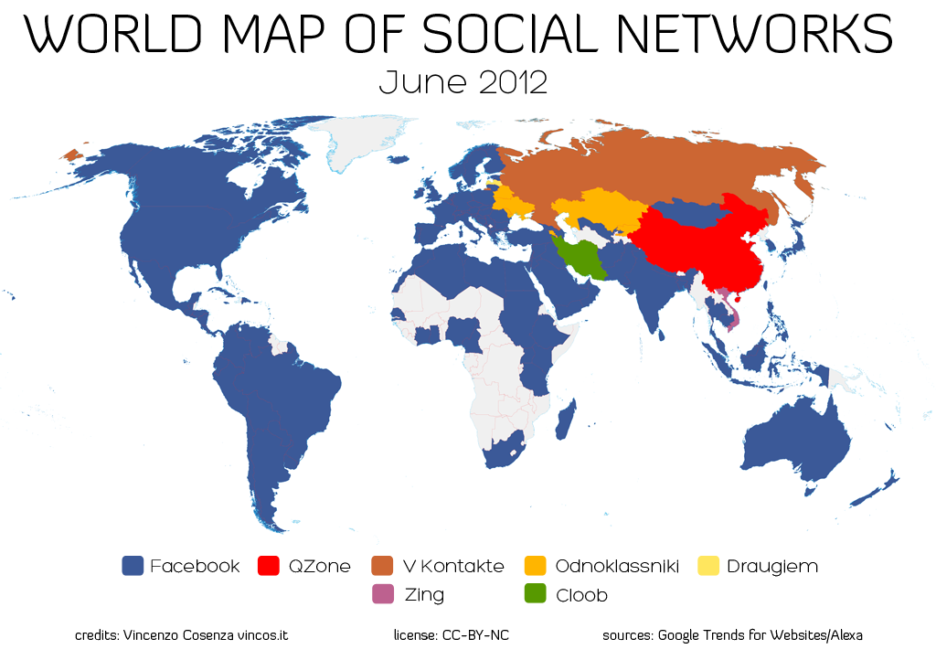
World Map of Social Networks
URL: http://www.hejorama.com/articles/the-monday-map-infographic-maps-10214/
This map shows what is the most popular social networks in different regions.Without the white area which is the region collectors do not have the data, blue makes most of the region. It is not surprise since Facebook is the most popular social network around the world. If Facebook is not blocked from China, China would have at least half to be blue. For China, it is the Qzone which dominates the market of the social networks, while another company, the Renren Inc., wants to the share the market. Also, for Russia and several other countries, many different social networks are the major players in those countries. It is interesting that this map vividly gives me a global image of the major social networks and countries they cover. As we can see, Facebook covers majority of the English speaking country since Facebook is more adaptable for people from Western country.
Subscribe to:
Posts (Atom)